Block Planning
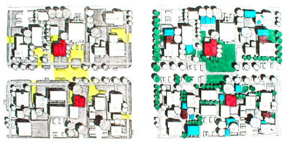
Theoretical Block Plan - Before, left; After, right
A picture is worth a thousand words. This graphic illustration shows a before and after of Block Planning. Remember, this is only one design. Some plans may be less ambitious while others might be even more dramatic. And also keep in mind, Block Plans must be within general guidelines set by the city and not in conflict with acceptable community and neighborhood values. Graphic by Mike Pease. Color interpretation by Jan Spencer.
Legend:
Red Orientation, houses on left and right are the same houses
Yellow Pavement "before" no longer in the "after"
Green New trees and open space
Blue New structures
Brown Garages into bungalows
To see examples of what Block Planning can look like, check these foto galleries.
East Blair, Eugene
Maitreya Eco Village, Eugene
N Street Co Housing, Davis, Cal -----------------------------------------------------------------------------------------------------------------------------------------------------------------------------------------------------------------------------------------------
Block Planning
A Block plan can vastly increase the scale and effectiveness of transforming where we live. A Block Plan is an agreement among residents and non-resident owners on a city block, with the approval by neighborhood and city, to develop the land within the boundaries of the block in a specific way over a specific period of time. In most ways a Block Plan is like a Planned Unit Development [PUD], of which Eugene already has many excellent examples. A BP would include agreements about planning, participation, construction, phasing, funding and maintenance and includes a process for making changes to the original plan. Where a Block Plan is in effect, it replaces the lot-by-lot, zone regulated development process that formerly governed. To the extent that block members wish it to, and City and Neighborhood approve, the Block Plan can revise yard requirements, land use arrangements, height restrictions, parking requirements, minimum lot sizes and so on; it can stipulate changes in use of rights-of-way and it can establish precisely where building development can occur and what type of building will be acceptable.
This explanation taken from "Block Planning: A Summary of Work to Date." Mike Pease Design and Planning Consultant, Willamette Community Design Center, September 1982.
Neighborhood Character Benefits
When people look at various places they might live, one of the priorities is what is the quality of the neighborhood. There are four basic qualities of any neighborhood's character that can be used to judge its character. Safety [crime and traffic], affordability [housing, taxes, insurance and maintenance]. Accessibility [ease of going to work, stores, schools, friends, recreation]. Viability [confidence that the neighborhood will continue to be a good place to live].
Block Planning can be an extraordinary tool, created and controlled at the block level, to help safeguard the neighborhood and more interestingly, IMPROVE many aspects of the neighborhood's livability. Block Planning is proactive, home grown and democratic. It is the people on the block who cooperatively determine how the block will be redeveloped.
Currently
As of Fall, 20013, Block Planning [BP] remains a tremendous but little known potential. It would take a considerable amount of effort and cooperation to actualize a Block Plan, but the potential social, environmental, political and economic benefits of redeveloping in this way are profound. Many city staff would love to see Block Planning, its up to neighborhoods to take the initiative to move BP forward.
Block Planning offers many benefits that can moderate the current economic downslide. Block Planning can lead to block economics - different ways to take care of human needs. Block Planning can also mitigate climate change and peak oil because a Block Plan can lead to more walkable neighborhoods and taking care of more needs closer to home. See below.
The graphic below is theoretical. It does offer a good idea of what a BP could include.
This part of the web page will explain Block Planning and provide some useful information about how to explore creating a Block Plan. Included here are diagrams of Block Planning as well of fotos taken in Eugene that show some of what Block Planning can look like. The fotos are not from actual Block Planning projects because none have been actualized to its full potential. Rather the fotos, taken from non BP locations, do have characteristics in common with what BP could look like. A Block Plan is the creation of the people on the block and could manifest in many different ways.
History of Block Planning
Mike Pease, Eugene architect, artist and smart land use advocate, evolved the concept of Block Planning over the course of his university days, travels and professional career. In the early 1980's the City of Eugene employed Mike, several colleagues and several UO graduate students as consultants and team to facilitate neighborhoods in Eugene to identify several potential locations to make practical application of Block Planning.
Several locations were identified including the Far West Neighborhood centered just north of 13th on Arthur Street. Another area was in Whiteaker on 4th Street just east of Blair Blvd. Another area was in West University on East 16th between Patterson and Ferry Streets. Another, also in West U was on 16th between Hilyard and Alder. Finally in the Westside Neighborhood, based on an alley bounded by West Broadway, West 10th, Jackson and Adams.
In all these areas, neighbors did meet to discuss Block Planning. The traffic calming circles on Ferry street are a result of that block's efforts. Elsewhere, preliminary diagrams were drawn. The area in Westside actually had zoning changes made by the city to accommodate the BP but the Plan was never implemented. The zoning changes are still on the books.
Why did none of the plans manifest? Partly because the process is time consuming. Partly because an economic downturn relieved development pressure on some neighborhoods that some residents felt uneasy about. They had seen Block Planning as a way to protect the character of their neighborhoods. Another short fall was that the city did not have [and still doesn't have] the resources to facilitate the process. Finally, a change in presidents. Carter to Reagan, meant that policies and budgets encouraging green innovation at the grassroots level came to an end.
Nearly 30 years has passed. It was a great idea 25 years ago. Its even far more relevant today.
Today's trends in economics, the environment, climate change, resources, social indicators all say Block Planning is more called for than ever.
Please see links above to see foto galleries of what Block Planning can look like.